Lachlan Fold Belt, NSW
Lachlan Fold Belt Copper-Gold & Silver Projects, NSW
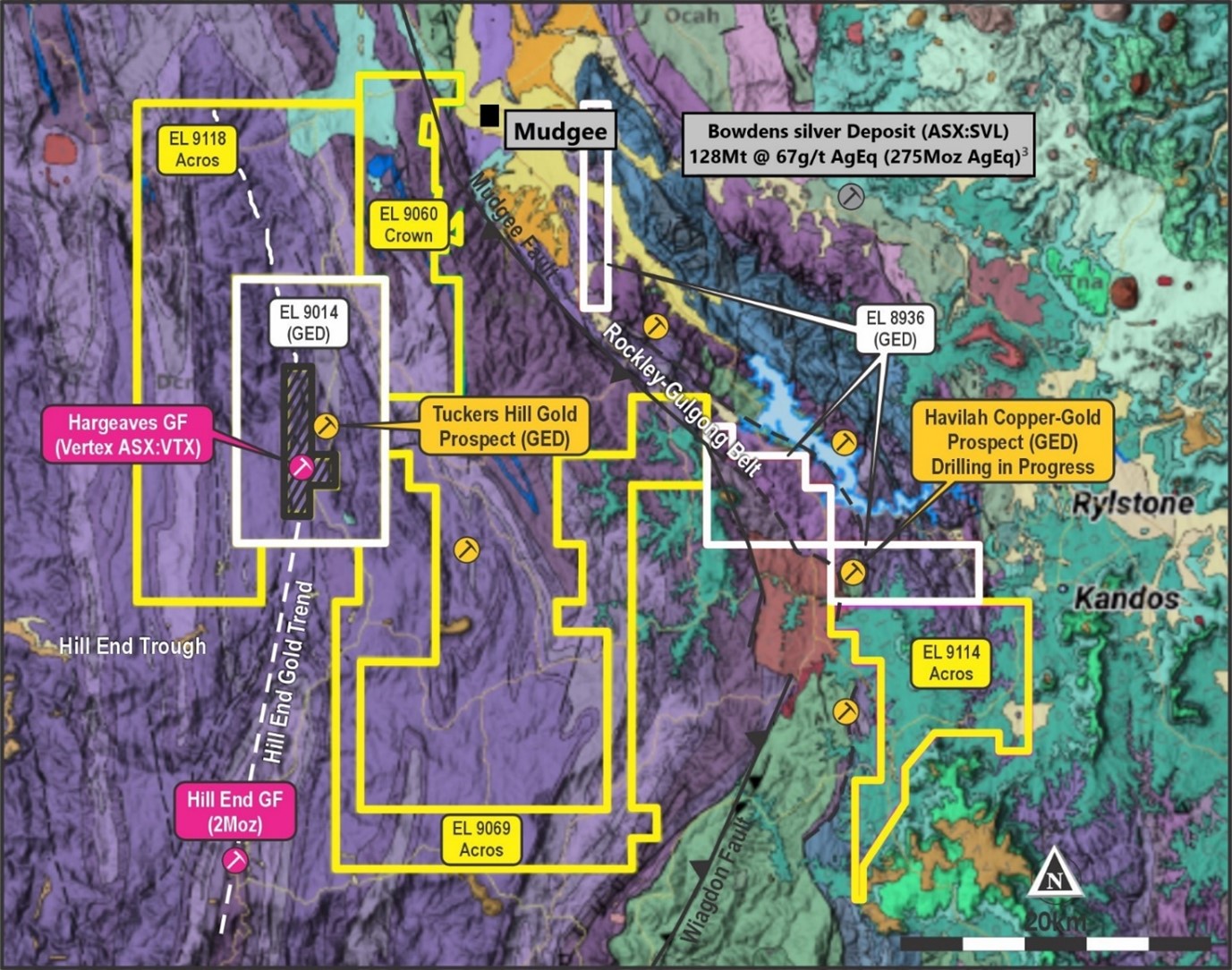
Golden Deeps has extensive tenements covering over 600km2 in the eastern Lachlan Fold Belt copper-gold province in New South Wales (Figure 1). The Lachlan Fold Belt is a high-profile mining and exploration region that contains several major gold, copper-gold and silver deposits. These include Newcrest Mining Ltd’s Cadia-Ridgeway Mine, Evolution Mining Ltd’s Lake Cowal Mine, China Molybdenum Co. Ltd’s North Parkes Mine, Alkane Resources Ltd’s Tomingley mine, and Silver Mines Ltd’s Bowdens deposit.
The Company’s tenements include the Havilah Project, the Tuckers Hill Project and the Acros and Crown JV tenements, which are located on the eastern margin of the Lachlan Fold Belt and straddle the boundary between the Siluro-Devonian Hill End Trough – which contains the Hill End gold field (2Moz produced), and the Rockley-Gulgong Volcanic Belt which is highly prospective for porphyry related copper-gold deposits (see regional map, below).
Havilah Copper-Gold & Silver Project
At the Havilah Project (EL8936) the Company is targeting porphyry/volcanic hosted copper-gold mineralisation in a belt of Ordovician age (Sofala) volcanic rocks in the under-explored Rockley-Gulgong Volcanic Belt – the eastern of four Ordovician volcanic belts in NSW, the other three hosting major copper-gold deposits.
At the Havilah Project the Company is targeting porphyry/volcanics hosted copper-gold and silver (Cu-Au-Ag) deposits in the Ordovician Sofala Volcanics and Carboniferous granitic intrusives. Mineralisation occurs on the tenement at the historical Milfor and Cheshire copper workings, within altered Sofala Volcanics that contain pyrite and chalcopyrite. Extensive stream sediment copper anomalism occurs across the northeastern margin of the Aarons Park batholith, which outcrops immediately to the southwest of the Havilah tenement. This granitic intrusion is associated with porphyry Mo-W-Cu mineralisation west of the Havilah tenement at the Mt Pleasant Prospect (see Figure 2).
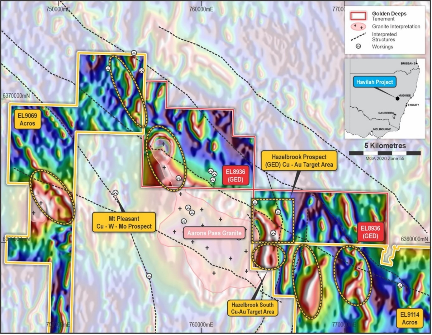
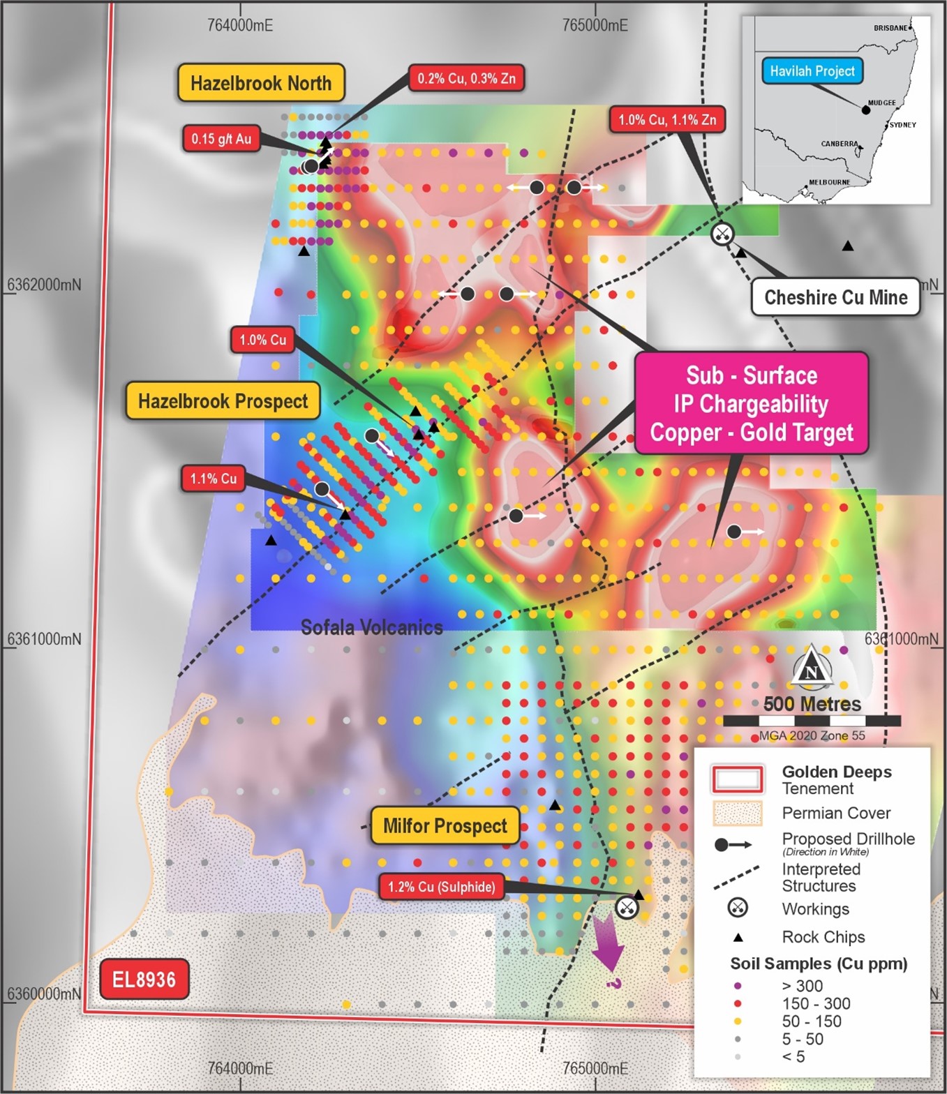
The Company previously announced extensive copper with gold, silver and zinc anomalies, including several values of more than 1% copper at the Hazelbrook and Milfor prospects (see Figure 3). Mineralisation associated with the strongly altered and mineralised Sofala Volcanics and northeast and north-south trending structures within the magnetic aureole of the Aarons Park Granite (see Figure 3).
The company is currently testing a series of porphyry/volcanics hosted copper-gold -silver (Cu-Au-Ag) targets associated with the Ordovician Sofala Volcanics and Carboniferous granitic intrusives and have similar geological and geophysical characteristics to major copper-gold and silver deposits elsewhere in the Lachlan Fold Belt. Key drill-targets include:
- Outcropping copper mineralisation (malachite, azurite and the copper sulphide, chalcopyrite) associated with a large northeast trending soil anomaly and several >1% copper rock-chip results at the Hazelbrook Prospect.
- A north-south trending silicified breccia zone with highly anomalous copper, silver, gold and zinc values at Hazelbrook North.
- Large, sub-surface, sulphide targets associated with strong Induced Polarisation (IP) geophysical anomalies and north-south trending gravity and magnetic corridors within the Sofala Volcanics.
Acros and Crown JV
The Company has entered into a binding Heads of Agreement (HOA) to earn an 80% interest in Acros Minerals Pty Ltd (Acros) and Crown Gold Resources Pty Ltd (Crown)(for details see announcement 12/07/24). Acros and Crown hold four granted and highly-prospective exploration licences adjoining GED’s current projects in the Lachlan Fold Belt Cu-Au Province, NSW(see Figure 1).
Targets within the Acros (EL9114, EL9069 & EL9118) and Crown (EL9060) tenements include:
- Extensions of the Sofala Volcanics south of GED’s Havilah Project. Magnetics indicate continuity of the highly-prospective volcanics and intrusives which project south under Permian cover into EL9114 (Figures 2 & 3). No previous work has tested the underlying volcanics and/or the intrusive boundary.
- Extensions of the Rockley-Gulgong belt along the Mudgee Fault (Figure 2), which includes the mineralised Sofala Volcanics and buried porphyry intrusion targets, which extend into EL9069 and EL9060, north of the Havilah tenement.
- Extensions of the Hargreaves / Hill End gold corridor (>2Moz of historical gold production). The high-grade gold corridor extends to the north of GED’s Tuckers Hill prospect, into Acros EL9118.
The Company will build on previous work which has shown that the mineralised Sofala Volcanics and porphyry Cu-Au targets are present on EL9114 and EL9069. Planned work includes further geophysical surveys (detailed gravity, magnetics & IP), with a focus on extensions of the Rockley-Gulgong belt south and north of the Company’s current drilling targets on the Havilah Project.
This work will aim to define drilling targets for major porphyry/volcanics hosted copper-gold deposits in an area which has received limited exploration due to shallow cover.
Tuckers Hill Gold Project
The Tuckers Hill Project (EL9014) is located ~20km southwest of the town of Mudgee in New South Wales (Figure 1).
The Tuckers Hill tenement is located in the Hill End Trough sedimentary basin and covers projected extensions of the Hill-End – Hargreaves and Tuckers Hill gold mineralised corridors (Figure 1). The Hill End goldfield produced approximately two million ounces of gold from orogenic quartz-vein hosted deposits within folded Devonian-aged sediments of the Hill End Trough.
Golden Deeps’ EL9014 tenement includes the Tucker Hill gold prospect, where stacked high-grade gold bearing quartz veins are targeted. The Tuckers Hill project is at the northern end of Vertex Minerals Ltd’s (ASX:VTX) Hill End Gold Project which has a Mineral Resource of 4.21Mt at 3.6 g/t Au (483,000oz contained gold).
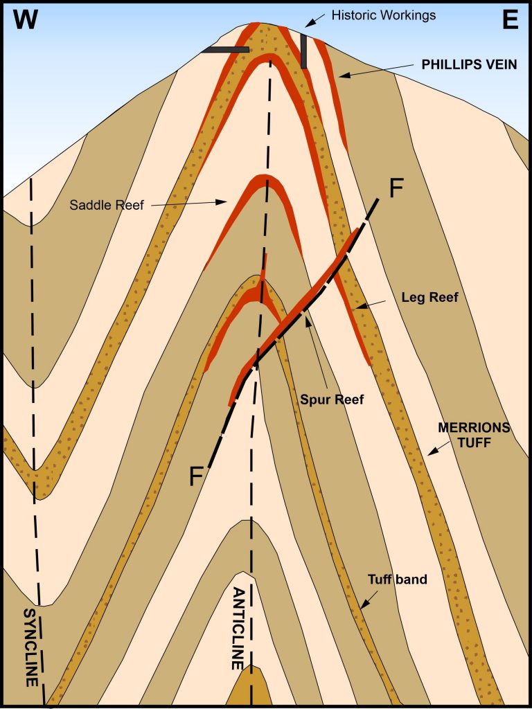
Previous geological mapping at Tuckers Hill has identified gold bearing saddle reefs and ‘leg’ reefs in a folded sequence of siltstone (slate) with minor sandstone, including a prominent volcaniclastic sandstone (Merrions Tuff). Tuckers Hill is an elongate north-northwest trending anticline that plunges to the north and south. Multiple saddle reefs have formed in the apex of the fold at the top of Tuckers Hill with narrow but high-grade ‘leg’ reefs on bedding contacts on the fold limbs (see Image 1 below).
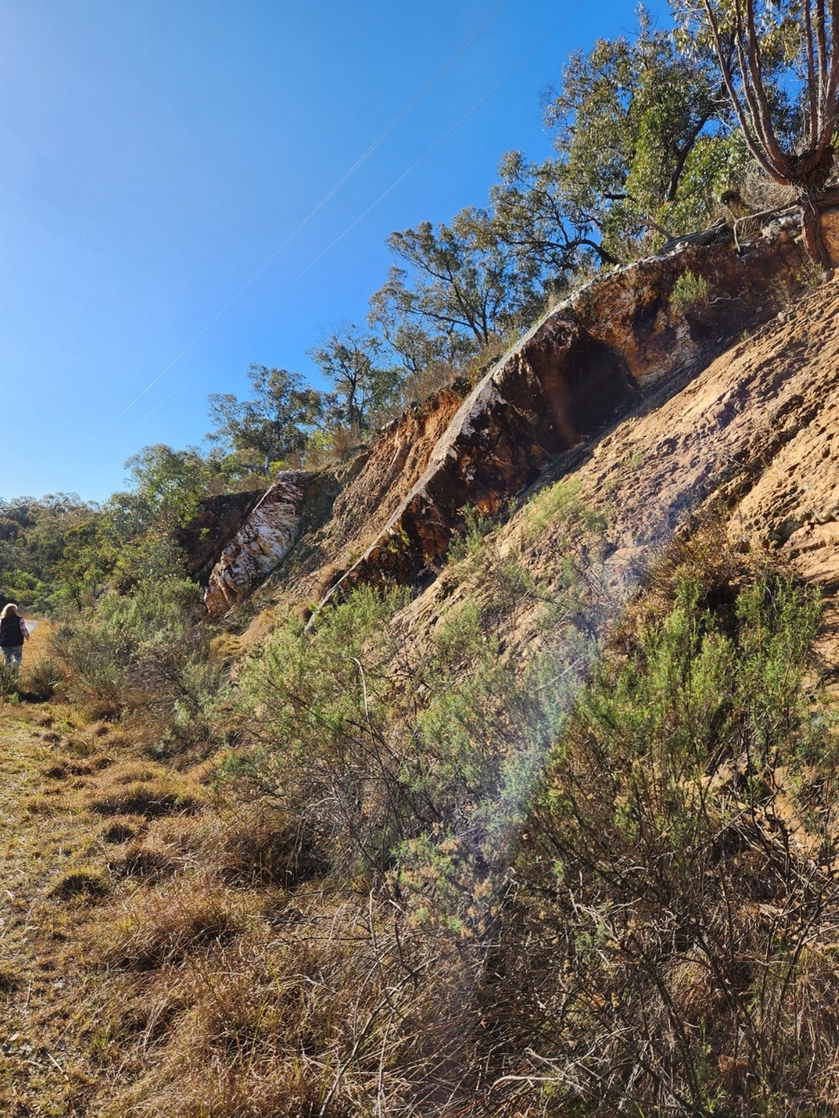
The Company completed Heritage and flora and fauna surveys over planned drillhole locations to test for saddle and leg reefs below Tuckers Hill (see Figure 4). Drilling will target the reefs down plunge to the north of the workings at the top of the hill which are on a series of parallel, high-grade gold veins with multiple assays over 1 g/t Au with a peak value of 28 g/t Au from sampling in 1980s.